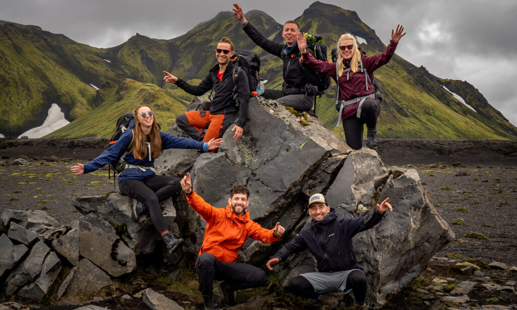

On the Harzer Hexen-Stieg (Harz Witches’ Trail), you not only experience a hike through a beautiful landscape but also a hike through one of the dark chapters of German history. It starts in Osterode, which is in former West Germany, and goes through the heart of the Harz National Park and across the old Border which separated Germany from 1961 – 1989. The trail itself is one of the German classics. Although it is not very long, the landscape is varied and there is much to explore. The route even goes on top of the highest point of northern Germany, the Brocken, with a height of 1141 meters. Besides the alpine landscape on the Brocken, you will also hike through deep forests, moors, and valleys.
We would recommend the classic variant of the trail which is about 100 km long. But there are also two official alternates, one to bypass the Brocken, and a south route to get around the large Rappbode water reservoir. Combined, this results in an official trail network of 154 km.
How long does it take?
That’s up to you. If you are looking for a challenge, you can try it in three days, if you want to explore more you will not be bored within seven days. We have done the classic variant following the Eckerlochsteig alternate in five days.
These are our recommended stages:
- Day 1 Osterode – Dammhaus | 19km
- Day 2 Dammhaus – Torfhaus | 15km
- Day 3 Torfhaus – Schierke | 18km
- Day 4 Schierke – Neuwerk | 23km
- Day 5 Neuwerk – Thale | 25km
Starting in Osterode
The starting point of the Harzer Hexen-Stieg is the town of Osterode, directly on the western edge of the Harz Mountains. Osterode is easy to reach by car, and there is also a train connection. From the railway station, it is only a few minutes’ walk to the large, free-of-charge Bleichestelle car park. This car park is also the trailhead for the hike. The path begins very relaxedly because the first half is wide forest paths and the dam ditch (Dammgraben), which doesn’t want to leave your side. You walk kilometer after kilometer along the man-made water channel. It was built in the 18th century to supply the Harz mining industry with water. Today, we as hikers have the great advantage of having a continuous water supply at our side.
However, you will soon reach the village of Torfhaus. From there you start directly into the eponymous Torfmoor and from there you already have the Brocken in sight. The climb from Torfhaus is very popular and so you will meet many other hikers on this section. Once you reach the top of the highest mountain in Saxony-Anhalt, you will be rewarded with a beautiful view. Unless you catch one of the 300 foggy days a year. The Brocken also marks the former border crossing and it was a restricted area until the beginning of the 90s.

Descend toward the east
After you’ve probably had a traditional pea soup at the Brockenwirt, there are many ways to get down from the Brocken. The official trail leads through the national park with the Drei Annen Hohe junction as the next option to rest. However, there would also be the possibility to take the historic steam train down to the junction, because believe it or not, there is a train station directly on the summit. However, the most interesting option for a hiker is to take the Eckerlochsteig alternate. If you feel like jumping from rock to rock, you should take this side trail toward Schierke. Because of its varied nature with large rocks and numerous waterfalls, it is a hidden gem for the regular Hexen-Stieg hiker. In addition, you pass the railroad tracks here several times. The passing locomotives are anyway more spectacular than if you were sitting in one of their wagons. We speak from experience. This trail leads directly into Schierke, one of the most beautiful villages on the hike. Also, it marks the halfway point of the route and offers itself with its many guesthouses for a break.
Along the Bode river to Thale
From Schierke it becomes a little quieter again. You meet significantly fewer hikers and infrastructurally it also decreases somewhat. The last part of the Hexen-Stieg is characterized by lonely villages, many reservoirs, and the river Bode. You meet the river for the first time in Könighütte, where you have to decide between the north and south variants. We choose the north variant because it promises more views. You follow the river to Rübeland, which is famous for its stalactite caves, and finally the edge of the dam with a view of the huge dam wall. After Neuwerk there is also the possibility to visit the “Titan RT,” one of the longest pedestrian suspension bridges in the world.
After that, the north and south variants converge again. The trail now leads into an ever-deepening valley directly along the riverside. Towards the end, the rock walls even reach a height of 250 meters. The main route will not take you to the top, but there are various ways to reach the famous viewpoints of Hexentanzplatz (witch dance square) or the Rosstrappe. The last meters of the trail lead through the Thaler town park to the terminus, which is across the road from the train station. There ends the Hexen Stieg and so you have crossed the Harz entirely by foot.

Preparation details
Where to sleep?
There are countless hotels and guesthouses along the way. If you go in the summer, you should book in advance. You can find some accommodation options here. There are only a few campsites along the trail, many of them too far off to get there by foot. Unfortunately, wild camping is not allowed in Germany and is strictly prohibited in the national park.
Best travel time
Like every low-elevation hike in Europe, spring and autumn offer the best hiking climate. But keep in mind that you can encounter much snow on the Brocken even in April. Also, some of the huts might still be closed in the early and late seasons.
Good to know
The trail is relatively well signposted, but the markings are somewhat sparse. Due to the permanent forest work in the Harz mountains, route closures occur every now and then, so you should navigate additionally with your cell phone.
Along the way, you often pass through small villages, but there is only a limited range of shopping opportunities, so we were quite happy to have packed food for the complete 5 days. Nevertheless, we passed an open guesthouse at least once a day, where there is always warm cuisine from noon onward. The water supply is also no problem, you constantly pass natural drinking water sources, and should be well supplied in combination with a water filter.
You do not need any permissions to hike the trail. But you can collect points at 222 stamp points to acquire the honorary badge, the Harzer Wandernadel. More info here.
Useful Links
More info: Official Website & Top Trails of Germany