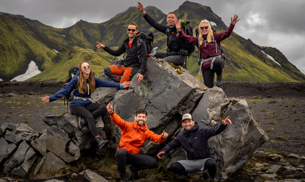

This may be the most well-known and most popular thru-hike in the world: the Pacific Crest Trail (PCT). The trail covers 4265 kilometers from Mexico to Canada through the American states of California, Oregon, and Washington; from deserts to the high peaks of the Sierra Nevada. With dense forests, mountain passes, plunging canyons, and vast expanses of rugged wilderness, the PCT has it all. The community around the trail also makes the PCT unique. Chances are that you’ll form a trail family with other thru-hikers and meet one of the many trail angels. Most hikers walk the trail northbound, meaning from south to north. Your goal is to reach the endpoint before the snow begins to fall. This trail is for you if you are looking for a unique long-distance walk and a challenge.
Southern California
The Pacific Crest Trail begins at Campo, a small town on the border with Mexico. Initially, you will mainly cross desert stretches. You walk through hills and over lower mountain ranges. Temperatures can reach 40 degrees and proper water supply planning is important. When you reach the mountain ranges of San Bernardino and San Gabriel, you will finally find some shelter in the woods. From here you continue through the hot Mojave Desert, before entering the Tehachapi mountain area and entering the Sierra Nevada. This section of the trail ends at the Walker Pass, which you cross at an altitude of 5246 meters.

Central California
For many, the next part is the pinnacle of the PCT. You will walk from the Walker Pass through the wilderness of Chimney Peak, before reaching Kennedy Meadows. Here you are in the breathtaking sierras. The ice-covered high sierras and glaciers provide many mountain lakes along the route. This section of the trail runs parallel to the John Muir Trail (JMT). The two trails come together and you conquer Mount Whitney at 4418 meters, the highest mountain in California and America (minus Alaska). From here, you descend to the Tuolumne Meadows of Yosemite National Park. The route here regularly descends through deep gorges, before crossing high mountain passes again. The Forester Pass at 4000 meters is the highest. After Sonora Pass, a relatively flat traverse begins until Interstate 80. You end this part of the trail in the Granite Chief Wilderness.
Northern California
From the Sierra Nevada, you walk to the southern Cascade Range. The forest areas are becoming more prominent. There is a good chance that you will encounter deer, black bears, foxes, and other wildlife here. You will cross Lassen Volcanic National Park and cross Highway 89. Further on, you walk through the dry Hat Creek Rim that reminds you of the first part of the PCT. Fortunately, you quickly descend toward the Sacramento River where the weather turns greener. Walk through the Marble Mountain Wilderness and descend to the Klamath River. Another climb to the top of the Siskiyou Mountains. The trail now continues in the state of Oregon.
Oregon
The trail in Oregon is considered the most “friendly” by many hikers. You can catch your breath after conquering the high peaks and passes in California. The trail remains at a fairly constant elevation with only the descent to and the crossing of the Columbia River Gorge worth mentioning. Enjoy the many lakes and water along the trail and walk Oregon’s Cascade Range. This is a volcanic area that makes the soil fertile and takes you through deep green forests. The largest and most active volcano is the majestic glacier-fringed Mount Hood. In this area, it rains more often, so you will find large subalpine-dense spruce forests. You end this part of the route through Oregon at the Bridge of the Gods.

Washington
One last push until you complete the trail’s endpoint in Canada. You start off with a long climb from the Columbia River Gorge and walk to the top of the Indian Heaven Wilderness. Continue towards the rugged North Cascades, which will put you to the test. Climbing, descending, climbing, descending, and so on. Traverse the Glacier Peak Wilderness, the North Cascades National Park, and the Pasayten Wilderness. The trail around Glacier Peak is one of the most scenic sections of the route. This part of the tour is the wettest and windiest. You will even find 750 eternal snowfields. After walking 4265 kilometers in all conceivable conditions, you reach the end of your thru-hike at the Northern Terminus.
Good to know
The Pacific Crest Trail is a demanding long-distance hike. Prepare well! The weather in the mountains can change quickly, therefore always keep a close eye on it. On the trail, you are often on your own. Keep in mind that you may encounter bears and take all precautions such as packing and hiding your food properly. Bring spikes for snowfields and always be informed by other thru-hikers and trail angels about the conditions on the route. In certain seasons there may be forest fires in dry areas. Most hikers walk the trail from south to north, starting in late April or early May. Your goal is to complete the Pacific Crest Trail without getting snowed on in the mountains, bringing your trek to an untimely end.
Useful Links
More info: Pacific Crest Trail